Alberta Land Surveyor
New Maple Geomatics Inc. simplifies the process of working with a land surveyor. Call us today at 587-232-9706 to discuss your needs and receive a quote. Learn MoreRequest a QuoteAbout Us
New Maple Geomatics Inc. provides professional land surveying services throughout Calgary and surrounding areas. We specialize in legal, municipal, and construction projects to meet all of your needs. Owner Stephen Hao, ALS, has been in the industry since 2007 and is an active member of the Alberta Land Surveyors’ Association and Professional Surveyors of Canada.
MISSION
Your peace of mind is our priority. At New Maple Geomatics we value our smaller clients just as much as the larger businesses and pride ourselves in providing every client with the personal attention and quality results they deserve. Whether you are a homeowner or a corporation, you can expect the same experience: transparent process, cost-effective options, and fast turnaround times.
When you work with us you can expect:
A detailed walkthrough of the process before work begins
An accurate, upfront assessment of all costs involved—no surprises
Appointments that work around your busy schedule
Friendly, knowledgeable professionals who have your best interests in mind
Respect for your property—we try our best to minimize any disturbances to your land
Our Services
Our service-oriented team is always looking for ways to better meet your needs. This includes staying current on the latest technology and advancements while still upholding established industry standards.

Real Property Report
A real property report clearly defines a property’s boundaries and physical features. It includes a detailed illustration, as well as notes on any areas of concern. New Maple Geomatics will prepare this legal document to ensure peace of mind for both property owners and sellers.
For more information please visit:
https://www.alsa.ab.ca/Public-Information/Real-Property-Reports

Fence Line Survey
Keep things neighborly with professional fence line surveys.This service identifies and marks your property boundaries, so you can set up your fence the right way and avoid legal disputes with neighbors. New Maple Geomatics is here to discuss your concerns and guide you in properly locating and marking your home’s boundaries for your new fence.
For more information please visit:
https://www.alsa.ab.ca/Public-Information/Fences

Condominium Survey
New Maple Geomatics provides professional surveys for a variety of condominium projects, including conventional condos, bare land condos, condo re-divisions, phased condos, condo conversions, and more.

Condominium Survey
New Maple Geomatics provides professional surveys for a variety of condominium projects, including conventional condos, bare land condos, condo re-divisions, phased condos, condo conversions, and more.

Development Permit Surveys
This survey is recommended for new development projects and involves site surveys, underground utility locating, lot grades, adjacent property footprints, and more. Since every project will be different, we suggest obtaining a complete checklist from the municipality outlining what needs to be performed for your new development. New Maple Geomatics will help you through the planning process andperform the survey to ensure you are appropriately prepared to carry out your development project.

Subdivision Survey
In subdivision surveys, a plot of land is divided into two or more areas; each plot is subsequently responsible for acquiring separate titles. This lengthy process is guided by your Alberta Land Surveyor at New Maple Geomatics. We act on your behalf to apply for subdivision and make sure the process is completed correctly, saving you the time and hassle of figuring out municipal regulations.
For more information please visit:
https://www.alsa.ab.ca/Public-Information/Subdivisions


FAQs
What is Real Property Report?
A Real Property Report or an RPR is a legal document prepared by an Alberta Land Surveyor illustrating permanent features on the property in relation to its boundaries. In previous years, an RPR would only show the perimeter of the property along with the permanent buildings with ties to its boundaries and any right-of-ways that affect the lot. In most cases, permanent features such as fences, concrete, decks, sheds and eaves were not included in the report. But that is not the case now. The standards for the RPR’s have changed over the years and more features are now indicated on the report, providing a better representation of what is actually on the property.
Encroachments into the subject property, onto a neighbouring property or into a right-of-way are clearly seen from the report. Violations to some municipal bylaws are also easily exposed. One of the purposes of an RPR is to protect the buyer’s interest. Before a property is sold, an RPR is usually provided to the buyers. Any problems or issues revealed by the report are to be dealt with by the seller.
A Certificate of Compliance is a confirmation provided by the City of Calgary indicating that the improvements within the subject property are in compliance with the current Land Use Bylaw.
Who needs a Real Property Report?
Property owners, to be informed of:
- The locations of improvements within the property boundaries,
- Any encroachments from adjacent properties, and
- Property compliance with municipal requirements
Property Purchasers, to be informed of:
- The boundary and improvement locations on the property, and
- Any problems relating to the property boundaries.
Municipalities, to assist them:
- In determining compliance with bylaws and fire codes, and
- In the planning and development process.
Property Sellers (vendors), to provide:
- Protection from potential future legal liabilities resulting from problems related to property boundaries and improvements.
Mortgage Lenders, to be informed of:
- Conformance of improvements with municipal bylaws, and
- Problems that may have to be resolved prior to registration of the mortgage
Realtors, to:
- Provide a visual representation of the property for sale,
- Meet requirements of the real estate listing/purchase contract, and
- Have information to avoid delays in completing property transactions when a Real Property Report is arranged early in the sales process.
How does a Real Property Report protect you?
Purchasing a property may be the largest financial investment you ever make. With a Real Property report, owners are aware of any boundary problems. They know whether their new home is too close to the property line, or part of their garage is on their neighbour’s land, or vice versa.
“Good boundaries make good neighbours!”
Since legal complications may occur if a sold property fails to meet requirements, a Real Property Report protects the seller.
What is Municipal Compliance and How Does it Protect You?
Municipal Compliance is a stamp of approval from the city or municipal district on a real property report to denote that all structures on the property are compliant with municipal bylaws. Some of these bylaws may include the distance from a building to the property line, retaining walls or other structures into utility right of ways, or the distance of a deck to the property line. The stamp of compliance ensures the buyer in a real estate transaction that the property they are purchasing complies with all bylaws. Early preparation of a Real Property Report significantly speeds up the process of selling a property.
How long is a Real Property Report valid?
Changes are often made to improvements on a property or adjoining properties. These may be new or modified fences, decks, driveways, garages or other features. Only an updated Real Property Report can show their location relative to property boundaries.
Changes to your title will also be shown.
How can I get a Real Property Report updated?
Contact the Alberta Land Surveyor who did the original Real Property Report. The Alberta Land Surveyors’ Association does not have records of who did any individual Real Property Reports.
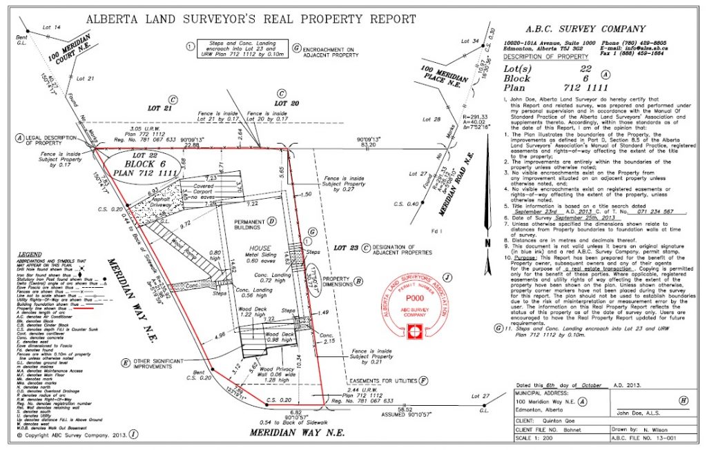
What is shown on your Real Property Report?
Your Real Property Report will show:
- Diagram from inside the Real Property Report brochure.
- Legal Description of property and municipal address (A)
- Dimensions and directions of all property boundaries (B)
- Designation of adjacent properties, roads, lanes, etc (C)
- Location and description of all relevant improvements situated on the property together with dimensions and distances from the property boundaries (D); for a list of the improvements which must be shown, refer to Part D, Section 8.5 of the ALSA’s Manual of Standard Practice.
- Other significant improvements (E)
- Right-of-way or easements as noted on the title to the property at the date of survey (F)
- Location and dimension of any visible encroachments onto, or off of, the property (G)
- A duly signed certification and opinion by an Alberta Land Surveyor (H)
- Copyright (I)
- Permit Stamp (J) (where applicable)
- A municipality may request additional information
How is a Real Property Report prepared?
A valid Real Property Report must bear the original signature and permit stamp of the Alberta Land Surveyor.
In preparing a Real Property Report, an Alberta Land Surveyor will:
- Search the title of the subject property.
- Search all pertinent encumbrances registered against the title of the subject property.
- Search all plans related to the location of boundaries of the subject property.
- Perform a field survey to determine the dimensions of the property and location of improvements. It will be necessary for the Alberta Land Surveyor to access property markers on the subject and nearby properties.
- Prepare a plan (diagram) reflecting the results of the field survey and title research.
How much does a Real Property Report cost?
The Alberta Land Surveyors’ Association encourages the public to discuss potential survey projects with an Alberta Land Surveyors prior to initiating any project. Discussions with an Alberta Land Surveyor about the specifics of the project should be undertaken to develop a better understanding of the costs and the complexity associated with the project. Some of the considerations that may impact costs include:
- Availability of survey evidence defining boundaries
- Current and historical title searches
- Other surveys in the area under consideration
- An Alberta Land Surveyor’s experience and resources available at the time of the project
- Travel and accommodation costs
- Application, endorsement, approval or record searching fees.
This list of considerations is not exhaustive but should form the basis for discussion prior to any project starting. It is incumbent on the public and the members of the Association to discuss potential projects so that a fair and reasonable value for the services being offered can be reached.
Who are Alberta Land Surveyors?
Land Surveyors are governed by provincial law with a mandate to protect the public’s interest in matter of real property boundaries.
Additionally, they must be registered with the Alberta Land Surveyors’ Association. An extensive practice review program ensures surveyors maintain high professional standards.
An Alberta Land Surveyor is fully responsible for the accuracy of the information in a Real Property Report. Land Surveyors carry professional liability insurance as added protection for the consumer.
Click here to find out who does residential or commercial real property reports in your area.
The benefits of a Real Property Report
Problems are identified and can be resolved before a sale is finalized.
Owners know accurate locations and dimensions of buildings, improvements, rights-of-way, and encroachments relative to boundaries of their property.
Purchasers know the physical dimensions of the property.
Financing usually requires verified survey information.
Property transactions are simplified.
Development and building permits require boundary information.
Contact Us
New Maple Geomatics Inc. simplifies the process of working with a land surveyor. Call us today to discuss your needs and receive a quote.
Calgary, Alberta
587.232.9706
info@newmaplegeomatics.com
Office Hours
8:00am – 5:00pm
Monday – Friday
Request a Quote
© Copyright 2019 New Maple Geomatics Inc. All rights reserved. Design by LBdesign Graphic Services.